- Community Spotlight, Uncategorized
- Environmental Resource Assessment & Management
CSS Employee Owners Receive NOS Team Member of the Year Awards

Congratulations to two CSS Employee Owner who received a National Ocean Service (NOS) Team Member of the Year Award for their dedication and hard work over the past year.
One employee owner received an NOS Team Member of the Year Group Award as part of Team Lynker, the prime contract company with NOAA’s Office for Coastal Management, and other federal team members responsible for announcing the Climate Resilience Regional Challenge funding. The CSS employee owner involved in this massive communication effort provided web support and designed materials to be used in communication regarding this funding, including a handout for each of the 19 projects. The team used these products to communicate to NOAA leadership, the public, the press, and Congress.
Another employee owner supporting the CSS contract with NOAA’s National Centers for Coastal Ocean Science (NCCOS) received an NOS Team Member of the Year Award for his exceptional performance in successfully transitioning and running models for hypoxia and harmful algal bloom (HAB) forecasts to NCCOS. To accomplish this transition, CSS employee owner had to become an expert in the model framework that had not previously been used at NCCOS. As part of this transition, he worked through and overcame unanticipated challenges while collaborating with partners to find solutions. In addition, he implemented the first forecast of movement of the HAB in Lake Okeechobee Florida. During these transitions he worked constantly looking for solutions to assure the processing is reliable will be sustainable in the long-term. Throughout the process, he documented procedures and provided training to enable others to run the models.
Congratulations to both employee owners on their amazing accomplishment and their well-deserved awards!
See More CSS Insights
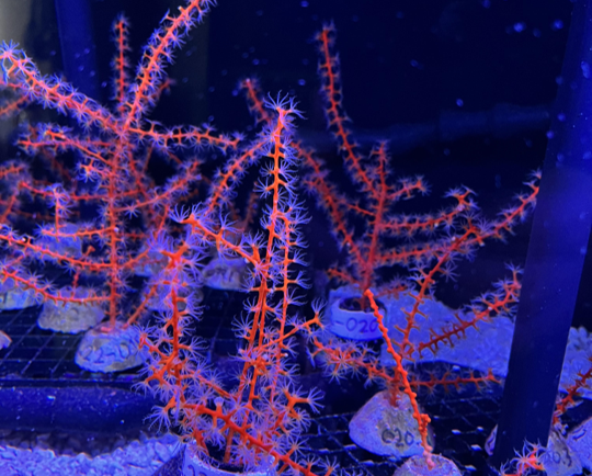
Studying Mesophotic Coral Health
Mesophotic coral can live at depths of 500 feet below the ocean surface. Even at this depth, some of the mesophotic corals in the Gulf of Mexico were affected by the Deepwater Horizon oil spill in 2010. Our coral scientists supporting NOAA’s National Centers for Coastal Ocean Science are studying the extent of this impact.…
Supporting the Launch of NOAA Data to Inform More Resilient Infrastructure Designs and Structures
Congratulations to NOAA for launching their new Typical Meteorological Year product, developed by the National Centers for Environmental Information (NCEI) as part of the industry initiative. This effort helps make environmental data actionable for architects and engineers designing the next generation of resilient infrastructure. CSS is proud to support this effort and our employee owners who contributed to this product. The Typical Meteorological Year (TMY) product provides location-specific…

Employee Owners Nominated for NOAA Gold Medal Award
Congratulations to CSS employee owners supporting NOAA’s National Centers for Coastal Ocean Science for their nomination for the NOAA Gold Medal Award! CSS employee owners have been critical members of the team charged with the rapid development of spatial models that aid in offshore wind planning in the Gulf of Mexico. The team has collected…